

Introduction and Overview of LifeSim
Introduction
An evaluation of the risk associated with flood defense infrastructure may be undertaken for a variety of reasons, including periodic risk assessments, regulatory compliance, emergency response planning, and assessment of risk reduction measures. Risk is a function of hazard, performance, and consequence. Therefore, evaluation of life loss and economic damage is an important element of these risk assessments as well as future planning and design efforts.
LifeSim was developed to:
- Effectively support reduction of life-safety risks associated with flooding;
- Evaluate existing and residual risks against tolerable risk guidelines;
- Calculate economic consequences (e.g., direct structural, indirect, and agricultural);
- Understand life-loss dynamics associated with floods; and
- Create or improve existing emergency action plans.
LifeSim is a spatially-distributed, dynamic simulation modeling system for estimating potential life loss and direct economic damages from flood hazards. It explicitly models the warning and mobilization of people potentially exposed to the hazard and predicts the spatial distribution of fatalities within buildings and on road networks expected to be impacted by the hazard. Although LifeSim was developed for dam and levee safety analyses, the software is not limited to failure flood hazards (RMC, 2021) [?].
LifeSim is founded on the LIFESim method developed by Utah State University's Institute for Dam Safety Risk Management (see, e.g., Aboelata and Bowles, 2005) [?]. The USACE Hydrologic Engineering Center (HEC) released the first version of HEC-LifeSim in July 2017. This technical reference manual reflects the initial release of LifeSim Version 2.0 and subsequent releases.
Purpose of this Technical Reference Manual
This technical reference manual describes the methods, procedural steps, and computations that LifeSim uses to calculate fatalities and damages resulting from floods or other hazards. A strong understanding of these internal processes will increase the user's ability to identify model limitations, provide suitable inputs, communicate the importance of results, and help validate decisions that LifeSim supports.
The format of this manual was designed to answer the following questions about LifeSim:
For each parameter:
- What is it, and what are its fundamental properties?
- How is it used by the application?
- How does it influence the simulation results?
- Why was the default chosen? Where did it come from? Why is it the best option, if it is?
- Where can you find more information?
- What should you consider if you want to change the value from the default?
LifeSim Overview
LifeSim simulates the outcomes of event-exposure (Aboelata, Bowles, and McClelland, 2003) [?]. Examples of events are dam failure, levee failure, or any flood of given severity. Exposure refers to the people and resources that are exposed to the event. Exposure cases can include different seasons, day/night, weekend/weekday conditions affecting the size and distribution of the PAR. Various aspects of a warning and evacuation system can be described and tested.
The key component of LifeSim's methodology is that the magnitude of life loss depends on whether people evacuate successfully and whether those who fail to evacuate can find adequate shelter (Aboelata, Bowles, and McClelland, 2003) [?].
Research by the original developers of LIFESim showed that warning time is a relatively poor predictor of whether people will evacuate successfully. The time that is required to evacuate may vary dramatically from one location to another based on how quickly emergency management officials can deliver individual warnings; how urgent, credible, and frequent the warnings are; the nature of sights, sounds, and vibrations that provide natural warnings; selected modes of evacuation; the mobility of the population in question; the size of family groups; the distance to safety; barriers, such as fences and bridges; and many other factors. For those who do not evacuate, survival depends on the ability to reach adequate shelter from the flood.
Factors affecting life loss include (Aboelata and Bowles, 2006) [?]:
- Flood severity
- Population at risk (PAR) location
- Downstream distance
- Elevation
- Structural resilience
- Warning system
- Coverage
- Effectiveness throughout the day
- Mobilization
- Believability of messaging
- Knowledge
- Roads
- Capacity
- Destinations
- Vehicle and human resilience
- Human mobility
- Willingness to evacuate
The progression of the hazard and people's responses to the hazard are dynamic processes, i.e., they are characterized by constant change over time. LifeSim simulates the interaction of these processes. For example:
- The hydraulic inputs are a spatially-distributed time series of depth and velocity of flooding.
- Evacuation modeling shows the spatial redistribution of population using dynamic simulation of vehicle traffic and pedestrian movement over time.
- During evacuation, interaction of people with the hazard is governed by time series of depth at structures and along roads.
- The loss of shelter study component provides progressive damage assessment throughout the flood event.
LifeSim uses agent-based modeling. An "agent" is an evacuating vehicle or a pedestrian group. Group size is a parameter defined at the occupancy type level (e.g., a school might be a group size of 30 to simulate school buses). During an evacuation, agents are interacting with the roads, other vehicles, and the incoming hazard. After the warning and evacuation process has been simulated, LifeSim calculates lethality for those people that are exposed and direct damages due to the hazard. Agent-based modeling allows LifeSim to:
- Track individuals throughout the warning and evacuation process.
- Identify where people are most at risk of losing their lives, whether it is on roads or in structures.
- Support a detailed analysis of a range of alternatives based on both structural and nonstructural measures for reducing potential life loss.
- Allow individual agent decision making through uncertainty sampling using Monte Carlo techniques.
LifeSim helps study teams better understand the consequences of a flood event by showing how loss of life varies as a function of time and space in addition to the following variables:
- Warning issuance time
- First alert diffusion
- The PAR's protective action initiation
- The PAR's evacuation potential
- Flood dynamics
- Loss of shelter
This information can be used to:
- Assess life safety risk reduction for planning purposes.
- Evaluate existing and residual risks against tolerable risk guidelines (see ER 1110-2-1156 for additional information).
- Understand life-loss dynamics associated with floods (or other hazards).
- Create or improve emergency action plans.
- Assess cost effectiveness or other justification of risk reduction measures (see EM 1110-2-1619 and ER 1105-2-101 for additional information).
Figure describes the general inputs needed to set up a LifeSim model and perform specified operations.
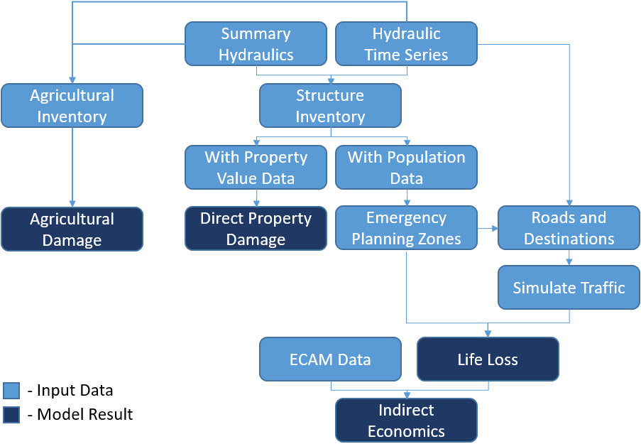
The following list includes general information required for any given scenario to construct a representative model in LifeSim.
- Hydrologic inputs, hydraulic inputs and system performance are needed to define the flooding scenario to be evaluated. These will include information about flood magnitude and timing, levee or dam performance functions, and floodplain inundation information. These variables are combined in a hydraulic model and imported into LifeSim as hydraulic events.
- Time for when consequences will be estimated, such as day or night, workday or weekend, and off-season or peak season for visitors.
- Information about the flood warning system for each study area or sub-area, and the probable response of the public to the warnings.
- Information about fatality rates as a function of flood water depth and velocity.
- Rural or urban nature of the study area.
- Critical infrastructure at risk.
- Sources and magnitudes of uncertainty.
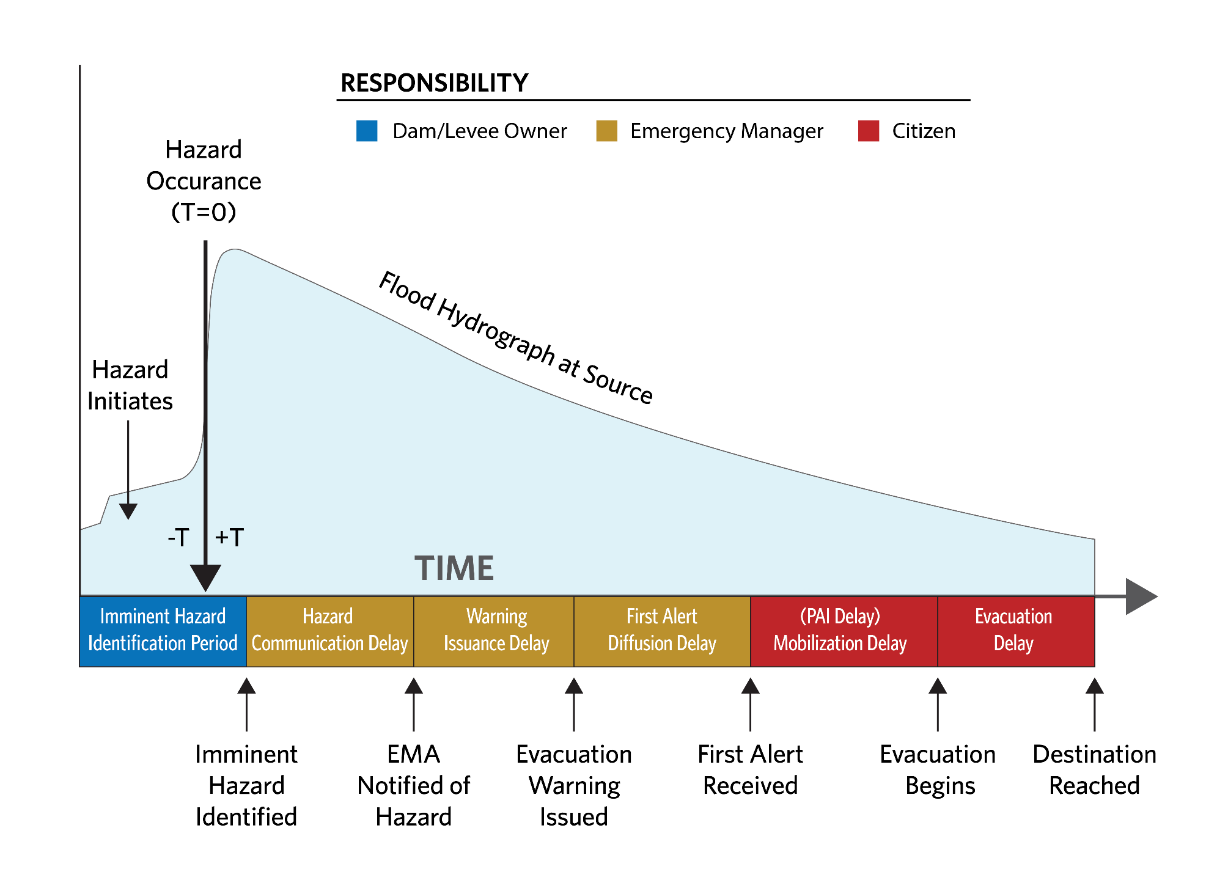
For analyses that include life loss, LifeSim is organized to follow a warning-evacuation (Warning and Protective Action Parameters) timeline that is enacted by dam or levee owners, emergency managers, and citizens, as shown in Figure. Each component of the warning-evacuation timeline is discussed in other parts of this manual (Warning and Protective Action Parameters and Road Networks, Destinations, and Evacuation Parameters).
LifeSim's Procedural Steps
LifeSim runs multiple iterations, or potential outcomes, through a Monte Carlo engine. The simulation period for each LifeSim iteration run commences with the earlier of the first evacuation warning or first hydraulic time step and continues until either the hydraulic time-series data has stopped or each evacuating group has finished their actions.
Given information about the hazard, PAR, structures, and road network, LifeSim does the following:
- Estimates the hydraulic characteristics (depth, velocity, and depth x velocity) at each structure and each road segment over time for a given flood event.
- Samples the time that a warning is issued to the population in each Emergency Planning Zone (EPZ) relative to the hazard occurrence (e.g., dam or levee failure).
- Separates the population into evacuating groups where the group size is determined by the occupancy type.
- Propagates the first alert throughout the population, and estimates the time that the population in each structure receives the first alert.
- Determines when each group will take protective action (if at all) once they receive the first alert.
- Determines if the group will attempt to evacuate to a destination or remain in their structure and evacuate vertically. Each group will attempt vertical evacuation if they do not leave the structure. If a group attempts protective action but water has already reached them, they will evaluate the non-evacuation depth at their structure or initial road. The non-evacuation depth for the initial road is determined by the group's threshold for willingness to enter a flooded road.
- Tracks evacuating groups on the road network as they evacuate. Evacuating groups become immobilized when:
- Their fording depth is exceeded, or
- A safe destination cannot be found when attempting to re-route.
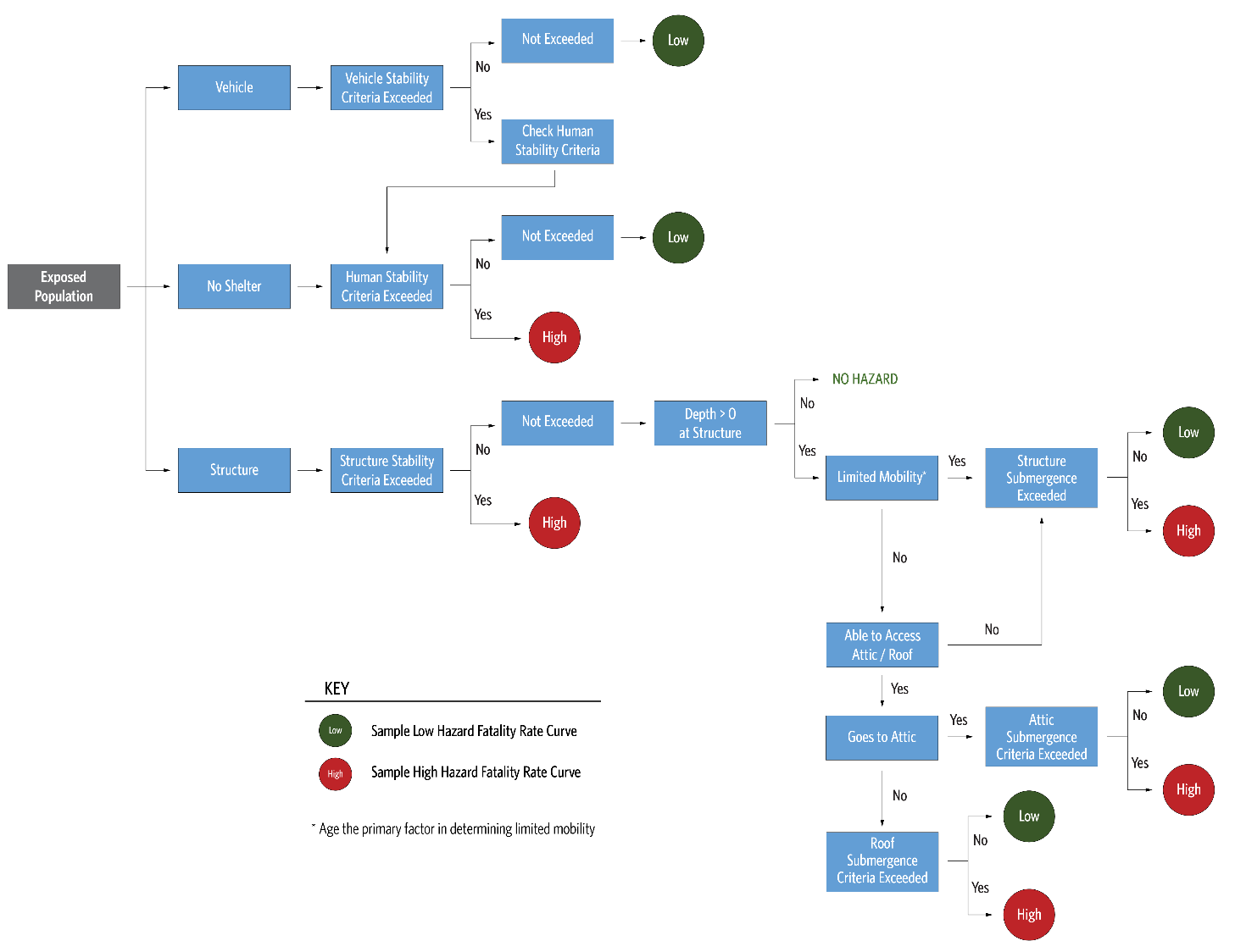
- Assigns groups to a hazard zone (none, low hazard, high hazard).
- People who evacuated and reached their destination safely are assigned to "none."
- People that mobilized but were caught are assigned to a hazard zone (low or high) based on the maximum hydraulic conditions of the road segment they are on and their vehicle/human stability.
- People who did not mobilize are assigned to a hazard zone (low or high) based on structural stability of available shelter and human submergence at maximum flood depths.
- Calculates life loss in each group by applying a fatality rate sampled from the assigned hazard zone to each person in the group exposed to the flood hazard.
- Estimates the total life loss as the sum of the life loss for all structures and vehicles caught while evacuating.
- Calculates direct property damages at each structure from the maximum hydraulic conditions at the structure using the structure's stability criteria and depth-damage functions sampled from the structure's occupancy type.
The flow logic for determining hazard zone for people exposed to the hazard (Steps 6–10) is shown in Figure.
For Steps 1–11, see Computational Procedure, Consequences, and Uncertainty and Sampling Methods for additional information.
LifeSim Validation Efforts
Calibration and validation of simulation-based life loss models such as LifeSim are challenging. Calibration of a specific model, which is the process of verifying that results match well with field measurements for a range of magnitudes of events, is obviously not possible. Validation of the methods in LifeSim to provide reasonable forecasts of potential life loss can be achieved by applying the model to historic events. However, the data required to properly validate the methods using a historic event are rarely available. Understanding where people were located at the time of the event, when they were warned, how they were warned, and the decisions they made related to if and how they evacuated is practically impossible to obtain (Needham, Fields, and Lehman, 2016) [?].
Nevertheless, USACE has successfully validated the methods in LifeSim with specific events. Each event's LifeSim model and description of its data inputs and lessons learned are available on this RMC Software Documentation website at LifeSim Validation Studies.
The validation efforts include the following events:
- Feijão Dam failure in Brumadinho, Minas Gerais, Brazil (2019),
- South Fork Dam failure in Johnstown, Pennsylvania, United States (1889),
- Kinugawa Levee failure in Jōsō (常総市), Ibaraki Prefecture, Japan (2015),
- New Orleans Levee System (validation effort available on East Bowl only) failure during Hurricane Katrina landfall in Louisiana, United States (2005),
- Kelly Barnes Dam failure in Toccoa Falls, Georgia, United States (1977),
- Malpasset Dam failure in Fréjus, Côte d'Azur, France (1959),
- Edenville Dam and Sanford Dam failures in Midland County, Michigan, United States (2020),
- Oroville Dam flood control outlet spillway emergency in California, United States (2017), and
- Teton Dam failure in Madison County, Idaho, United States (1976).
The validation efforts show that the LifeSim methodology, including its assumptions on various inputs, provides results reasonably close to what happened (Needham et al., 2020; Risher et al., 2017) [?] [?].