
Jōsō
Kinugawa Levee in Jōsō (常総市), Ibaraki Prefecture, Japan.
🡇 Download ModelOverview
In September 2015, moisture from Typhoons 17 (Kilo) and 18 (Etau) converged over northern Honshū (本州) Island, Japan. Intense rain bands stalled between the cyclones over the central mountain range and produced exceptional rainfall up to 660 mm over five days. On the Kinugawa River, four flood control dams spilled and sent record flows down the steep river. The river rose quickly (10 meters over 24 hours) and prompted warnings of possible flooding.
On September 10, 2015, a low point began to overtop in the municipality of Jōsō and erode the natural high ground. Floodwaters inundated rural neighborhoods and hectares of rice fields. The river continued to rise and overtop other low points in the left bank levee. Shortly before 1:00 PM, a 4-meter tall levee breached directly adjacent to several homes, releasing a powerful flood wave capable of toppling homes and floating away cars. The breach flow combined with upstream flow from a minor breach and overbank flooding. Inundation began to pool near the downtown area of Jōsō, trapping hundreds of people in their homes.
The disaster resulted in two fatalities.
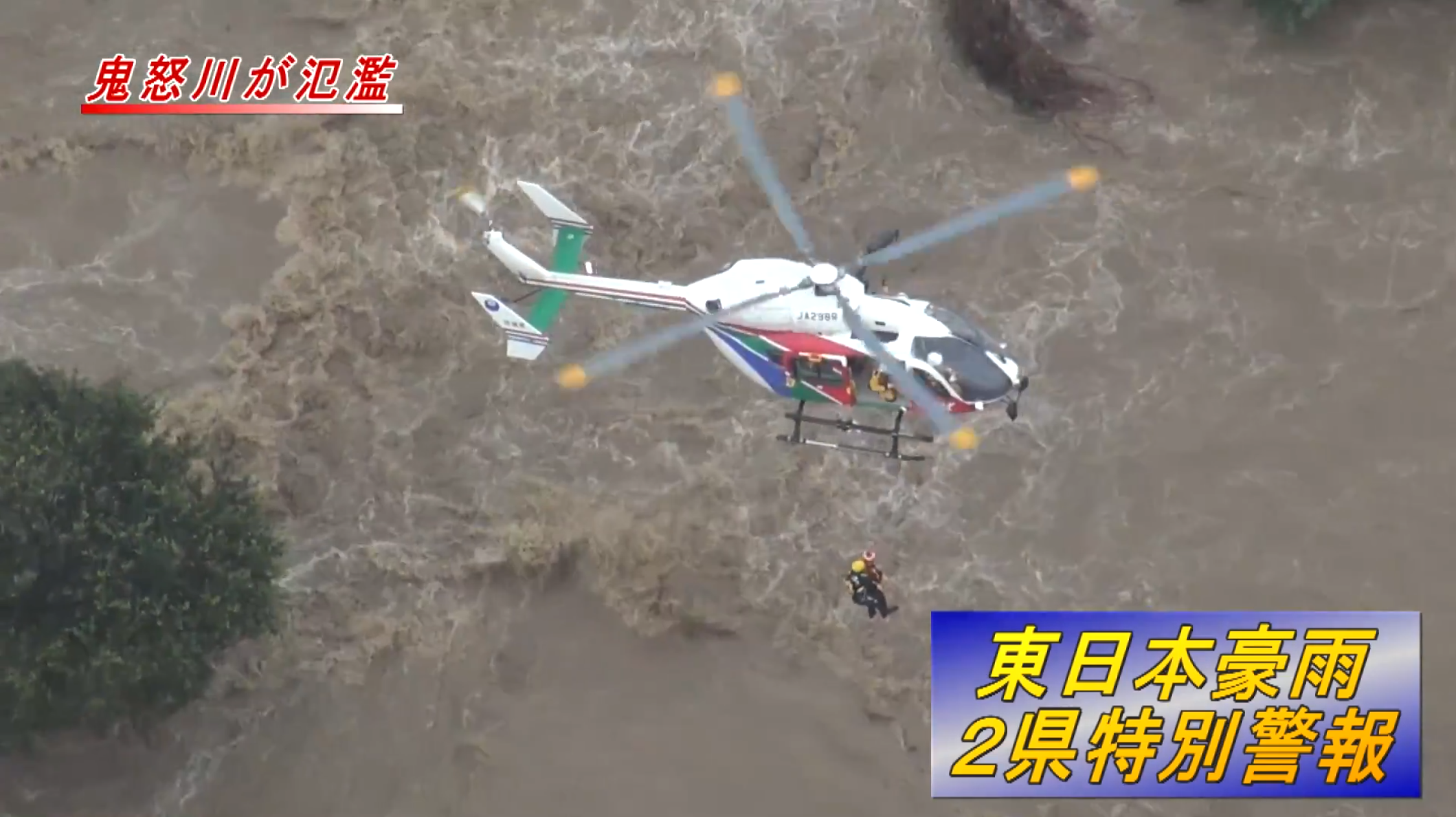
National and local government agencies responded by performing thousands of rescues by air (Figure), water, and even carrying people to safety on their backs.
Data
The complete Jōsō validation study analysis is documented in Risher et al. (2017) [?].
The following provides a short description of the data sources used for validation. Excerpts from Risher et al. (2017) are used to describe the model data.
Hydraulics
River hydraulic modeling started with pre-flood LIDAR terrain data for the Kinugawa and flooded area.
Calibration of the hydraulic model used data from a variety of sources. Several time-stamped aerial photos and Japan’s Geospatial Information Authority (GSI) maps outlined the flood limits. Geo-located photos of high-water marks provided over seventy-five maximum depth estimates. Time-specific depths came from photos, video, and eyewitness descriptions.
Calibration focused on arrival time and maximum depth – the two criteria most important to evacuation and life loss modeling. Velocities were also spot checked where structures failed. Additional calibration of pumping would be very difficult due to lack of information, so the model simulation terminated at that point.
Structure Inventory
A structure inventory was created by manually placing a point on each building observed in recent aerial imagery. The limits of the survey were the Kinugawa River on the west, the Kokaigawa River on the east, and a 100-meter buffer beyond the observed flooding limit to the North and South.
The structure locations were checked against OpenStreetMap [?] while the other parameters were checked with Google Street View.
The population estimate for Jōsō-shi started with 2010 adjusted census data at the neighborhood level (Statistics Bureau, 2015; GIAJ, 2014) [?] [?]. It was indexed based on 2015 population growth rates at the shi level and applied uniformly across all census blocks within the shi. There was a small decrease in population from 2010 to 2015. The final population estimate was 28,052 in Jōsō-shi and 33,219 total, including small parts of adjacent shi that were flooded. The model population is split into groups over and under age 65 based on the 2010 shi-level ratios (roughly 21-23% elderly).
Using video and other evidence of the rescue effort, the homes in the breach area were populated with the correct number of people at home. Foundation heights, construction materials, number of stories, and other attributes were refined further to ensure the proper depth and structural stability curve would be applied.
Road Network
The road import tool in LifeSim sources from OpenStreetMap data, available under Open Database License [?]. Each road segment has a traffic capacity rating based on its size and design (e.g., highway vs. street). The team checked the network for one-way streets, unnecessary segments, and traffic capacity to prevent too many people trapped on roads while evacuating. Any bridges or elevated roads are vertically offset to prevent them from flooding.
Destinations
Destinations were set at each bridge out of the leveed area and roads leading north and south out of the flooded area.
Emergency Planning Zones
In Japan, as in the U.S., local municipalities give evacuation warnings while a national agency gives severe weather statements. Evacuation warnings come in the form of pre-evacuation information, evacuation recommendations, and evacuation orders. All three types of warnings were given at various times and places by local government officials based on their perception of the risk. For modeling purposes, it was assumed people outside of the warned zones may still have gotten a warning unintentionally or indirectly, but the warning dissemination will be slower.
The Protective Action Initiation (PAI) curve defines the time when evacuation begins. Typically, a maximum rate is set below 100% because some portion of the population will choose not to leave or cannot leave. For this event, the maximum rate was set at 58.5% based on responses from the survey. This rate aligns with anecdotal evidence from Japan that evacuation rates are typically low, but there is no solid information about how many, how fast, or by what means people evacuated.
The PAI curve is the most uncertain parameter in the consequence model due to the lack of information. There were reports of traffic congestion and thousands of people in shelters. However, there were also thousands rescued by boat and helicopter, and people reaching safety on-foot through the flood. Rescue and sheltering are not accounted for in model evacuation.
Alternative
To simulate the staged warnings and mix of official and unofficial warnings, each Emergency Planning Zone was given its own warning time relative to breach initiation.
Critically, the zone nearest to the breach zone was assumed to receive warning after breach; however, population-at-risk were removed from the structures near the breach from available evidence suggesting the homes were empty at the time of the breach.
Modeling Conclusion
LifeSim performed well considering it could not account for rescue. The evacuated population was likely higher than expected pre-event. If the model results are an indicator, heroic efforts and rescues reduced the life loss significantly from structures that eventually collapsed and cars that overturned. It also seems that a strong community fabric exists in Jōsō – one concerned with evacuating the elderly and less-mobile people. Where modeling showed several fatalities to this vulnerable group, none occurred in Jōsō outside the breach zone.
Additionally, the following lessons were identified:
- Evacuation orders should consider the expected movement of floodwaters, and be coordinated with neighboring jurisdictions as early as possible. Warnings were sent haphazardly and neglected several areas at risk. Local shelters were opened in areas that should have been expected to flood and were indeed inundated, trapping many people. Agreements had to be reached during the emergency with neighboring municipalities to shelter evacuees out of the flooded area.
- Video and photos taken during the breach event were very valuable to post-event analysis of the hazard and consequence research including breach erosion progression. Efforts should be made to collect this information while it is fresh following dam and levee failures to aid in analysis later.
- Although National government agencies knew of the levee and river status before and during the event, the local government agency was not able to evacuate residents in time. This was due to both inadequate communication between agencies, and lack of capability at the local level to interpret the available information and take action. Since the incident, the Federal government has taken the initiative to communicate river conditions directly to impacted residents.
- A detailed breach and flood hydraulics model, coupled with an agent-based evacuation and consequence model provided valuable insight to the hazard progression and damages. They were calibrated with video, photo, and other observations such as stream gages. These tools may provide value for planning efforts by increasing understanding of the impacts of inadequate warning time as it relates dynamically to the progression of the flood.
Model Version
The original LifeSim model was developed in 2017 using LifeSim version 1.0 beta. The public model was updated in 2025 to LifeSim version 2.1.5 and produced negligible changes from the original documented results.