
Kelly Barnes
Kelly Barnes Dam in Toccoa Falls, Georgia, United States.
🡇 Download ModelOverview
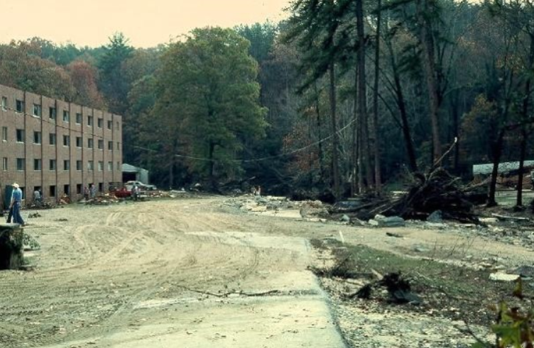
Kelly Barnes Dam – located above the Toccoa Falls Bible College near Toccoa, Georgia – failed in the early morning hours of November 6, 1977. The flood wave plummeted over the 186-foot tall Toccoa Falls and crashed through the Toccoa Falls College community. The resulting flood caused 39 fatalities and inundated a majority of the college campus (Figure), nearby residential homes, and a downstream trailer park.
The Kelly Barnes Dam breach was chosen for the LifeSim validation effort because of the robust quantity of details diligently recorded by engineers and historians on the failure. In the community impacted, data is available to locate nearly every structure and fatality in the wake of the flood. Also available are written and detailed firsthand accounts of the flood, which allow for uniquely detailed comparisons between the model and historical accounts that are impossible in most cases due to lack of data.
Data
The following provides a short description of the data sources used for validation.
Hydraulics
A single hydraulic event was created for this analysis based on Report of Failure of Kelly Barnes Dam, Toccoa, GA published by the Federal Investigative Board in 1977 (Federal Investigative Board, 1977) [?] and the USGS Hydrologic Investigations Atlas HA-613 (Sanders & Sauer, 1979) [?].
Hydrologic Engineering Center's River Analysis System (HEC-RAS) version 5.0.7 was used to develop a 2-dimensional (2D) hydraulic model of the study area. The hydraulic model begins at Barnes Lake and ends at Highway 17. Water is routed from both the primary and secondary spillways until failure.
The terrain used for this model originates from a 3m resolution DEM obtained from the USDA Data Gateway as part of the National Elevation Dataset (NED). A new spillway profile was cut into the terrain using tools available in HEC-RAS and elevations provided in HA-613.
Structure Inventory
Structures included in the structure inventory were located and defined based on the building footprint maps included as part of the USGS HA-613 (Sanders & Sauer, 1979) [?] and Dam Break in Georgia: Sadness and Joy at Toccoa Falls [?]. More information was found from Google Earth aerial imagery, as well as photographs and personal testimony provided by the Toccoa Falls College.
The population data for the structure inventory was created using only historical accounts and documents which linked population to structures at the time of the flood. This data is based primarily on Dam Break in Georgia: Sadness and Joy at Toccoa Falls [?]. This publication includes details and personal stories from the night of the flood and accounts for the locations and nature of all 39 fatalities.
Road Network and Destinations
The road network was imported from OpenStreetMap (OSM) [?] and minor modifications were made to match historical images.
Destinations were chosen at four locations to allow evacuees the most direct route to high ground.
The road network and destinations, however, have very little impact on model results due to the very short warning time. In very few iterations are there any evacuations on the road network. The road network is used more heavily for simulations created for validation of the U.S. Army Corps of Engineers (USACE) Modeling, Mapping, and Consequence (MMC) Production Center standard operating procedure.
Emergency Planning Zones
Toccoa Falls was modeled under a single Emergency Planning Zone (EPZ). First Alert and Protective Action Initiation were set to unknown, as both of these parameters are dependent on the readiness of the community – of which there is very little data to inform.
A sensitivity analysis was done on this parameter by creating two alternative EPZs using the default slow and fast parameters. Due to the short warning time, the effect of these parameters is negligible. Among the sensitivity analysis alternatives, mean life loss varies between 48.69 and 48.90.
Alternative
No formal warning was issued during the Kelly Barnes Dam breach because the hazard was not identified until the flood wave reached town. For this reason, the Imminent Hazard ID Time is set to 0.2 hours after the breach, which is the amount of time post-breach it takes the flood wave to reach the upstream end of town and marks the location where the danger can first be seen from town.
Hazard Communication Delay and Warning Issuance Delay do not accurately represent the warning scenario because evacuation is driven by individuals seeing the threat, choosing to evacuate, or choosing to warn neighbors. In this scenario, there is no communicating the threat to an emergency management entity or issuing a warning; therefore, these parameters are set to zero.
Modeling Conclusion
Due to the heavy documentation available (Foster & Mills, 1978) [?], model disagreements from the historical accounts are able to be identified and analyzed.
The following is a compilation of structures in the model validation simulation for which the historical recorded life loss does not fall within the bounds of the 25th to the 75th percentile of the model results, with an estimated modeling explanation.
| Structure | Historical Account | Model Explanation |
|---|---|---|
| Forrest Hall | Three drowned in the basement of the 2-4 story brick dormitory. An estimated 75 were in the building on the night of the dam breach. Four students had escaped from the basement seconds before it was flooded to the ceiling. | LifeSim does not consider the added risk of having bedrooms in the basement. There is added difficulty in evacuating vertically due to an additional story to climb, particularly when flooding comes as a surprise. |
| Guard Shack | Guard shack normally occupied by two guards. Both had evacuated to LeTournou Hall. No formal warning was sent out, but the shack was close enough to the stream that when minor flooding began (before the dam breached), it was enough to convince them to evacuate to higher ground. | The guards' evacuation was not driven by a dam breach hazard, but by the expected “typical” flood hazard. Modifying the model to include an individual Guard Shack EPZ would better model this early warning. |
| Eby House | Dave Eby (Dean of Men) and five other occupants were washed out of the house but swam back in after spending time on the roof. Barbara Kim (mother) and two others clung to the wall divider inside the house, with max depth inside about neck-deep. All survived. | The occupants all survived by floating in the structure or on furniture, whereas modeled results estimate this survival to be unlikely. |
| Nicholson Trailer | Four occupants inside. All survived. The individuals saw several trailers and buses floating away. Their trailer floated off its foundation, and they all floated out on a foam mattress. All were rescued from the water. | The historical account of the evacuation method and circumstances are extreme, and it is reasonable to believe that the modeled life loss is appropriate. The Nicholson family were able to survive despite the odds being against them. |
| Smith Trailer | Three fled their trailer on foot. They were caught by the flood wave as they ran toward upper Trailerville. The father grabbed the Pinney car and floated to safety just before it sank. The child (age 10) was pulled and rescued from the flood. | The Smith family survived by fleeing on foot or floating along. Fleeing on foot was not possible in the LifeSim model due to the lack of a formal warning being issued. |
| Kemp Trailer | Five occupants: two adults, two children, and one elderly. It was the first trailer to float. The floor collapsed. One child could not be held and lost his life. The elderly occupant floated to safety on furniture. | Occupants survived by floating in the structure or on furniture, whereas modeled results estimate this survival to be unlikely. |
Model Version
The original LifeSim model was developed in 2019 using LifeSim version 2.0. The public model was updated in 2025 to LifeSim version 2.1.5 and produced negligible changes from the original documented results.