

Appendix E - Structures from the NSI Database
All National Structure Inventory (NSI) technical documentation and references are available from the U.S. Army Corps of Engineers (USACE) Hydrologic Engineering Center (HEC) NSI Technical References webpage [?].
Release Notes for the NSI 2026 update document the major changes from the NSI 2022 base dataset.
Purpose
The NSI is a collection of point-based structure inventories used to support natural and technological hazard consequence analysis. The NSI provides consistent structure locations and attribution, including occupancy type, square footage, foundation characteristics, population estimates, and economic value estimates. Flood risk analysis is the primary use case, but the data structure also supports consequence analysis for other natural and man-made hazards.
The 2026 base dataset is a nationally consistent modeled inventory. It is intended to provide a practical starting point for consequence analysis where more detailed local inventories are unavailable, too costly to produce, or infeasible within study time constraints.
Background
The NSI base layer was created and is maintained by USACE. It was originally developed to simplify geospatial preprocessing for consequence modeling, but it has since been used in a variety of USACE, Federal Emergency Management Agency (FEMA), and interagency applications.
The NSI includes point locations for structures and a standardized set of attributes required by hazard consequence models. These attributes are exposed through downloadable datasets and a RESTful API. The standardized schema allows analysts and software tools to work with inventories from different locations and sources using a common set of fields.
Accessing the NSI
Data from the NSI can not only locate structures, but also populate structures with the attributes included in a structure inventory. The NSI dataset is separate from the LifeSim program but can be imported directly in LifeSim as a sole source or to supplement a user-defined inventory.
The NSI is available in GeoPackage, GeoParquet, and GeoJSON formats. State-level GeoPackage and GeoParquet files can be downloaded from the NSI Download Tool. GeoJSON files can be requested for individual counties or user-specified bounding boxes through the NSI API.
Data
Attribute Fields
The NSI API uses a standardized set of public fields to describe each structure record. These fields support common consequence modeling workflows, including structure damage estimation, life safety analysis, population exposure, and economic loss estimation.
Datasets added to the NSI must conform to the required schema. When values are not directly observed, analysts are responsible for providing reasonable estimates and documenting the assumptions used to populate those fields. At present, the publicly available NSI Base layer is maintained by the NSI development team. Future upload functionality is expected to allow additional inventories to be added using the same schema. Table lists the public fields currently exposed in the NSI Base schema.
Private fields restricted to Federal users and mission partners may be found at the NSI Technical References webpage.
| NSI Field Name | Description |
|---|---|
| fd_id | Unique for all structures. |
| bid | A building ID. This is the north axis aligned "bounding box" of its footprint represented as the centroid (in grid reference system format) and four cardinal extents. |
| x | X coordinate of each structure; it is in the Geographic Coordinate System (GCS) WGS84. |
| y | Y coordinate for each structure in GCS WGS84. |
| cbfips | Census Block that contains the structure. Currently, the NSI refers to 2020 census blocks. |
| st_damcat | Damage category of the structure. Damage categories are a larger aggregation than occupancy type (e.g., Residential, Commercial, Industrial, or Public). |
| occtype | Damage Function or Occupancy Type of the structure. This field relates the structure's depth-damage relationships, number of stories, number of households, and other generic characteristics to the structure location. |
| bldgtype | Building type of the structure. Commonly associated with exterior wall and used for structure stability functions (i.e., M = Masonry, W = Wood, H = Manufactured, S = Steel). |
| source | The source of the initial iteration of the structure (i.e., P = Parcel, H = HIFLD). |
| sqft | The estimated Square footage of the structure. This field is used when estimating the depreciated replacement value. |
| ftprntid | An identifier of the building footprint record used for estimating fields such as sqft and num_story. Stacked structures will share the same footprint ID. |
| ftprntsrc | The source of the utilized footprint (i.e., Bing, Oak Ridge National Labs, National Geospatial-Intelligence Agency). |
| found_type | Describes the type of foundation on the structure (C = Crawl, B = Basement, S = Slab, P = Pier, I = Pile, F = Fill, W = Solid Wall). |
| found_ht | Describes the foundation height of the structure in feet from the ground elevation. |
| num_story | The number of stories of the structure. |
| val_struct | Value in dollars of the structure. The base NSI estimates depreciated replacement value. |
| val_cont | Depreciated value in dollars of the contents of the structure. |
| val_vehic | Depreciate value in dollars of the vehicles at the structure. |
| med_yr_blt | Describing the median year built of structures within the Census tract. |
| pop2amu65 | Population at night for the structure of people under the age of 65. |
| pop2amo65 | Population at night for the structure of people over the age of 65. |
| pop2pmu65 | Population during the day for the structure of people under the age of 65. |
| pop2pmo65 | Population during the day for the structure of people over the age of 65. |
| students | Number of students attending the school as estimated by the source NCES data. |
| o65disable | The percent of the county population over the age of 65 that is expected to have an ambulatory disability. |
| u65disable | The percent of the county population under the age of 65 that is expected to have an ambulatory disability. |
| firmzone | Estimated 2025 flood zone for the structure. |
| grnd_elv_m | Ground elevation (in meters, NAVD88) at the structure. |
| ground_elv | Ground elevation (in feet, NAVD88) at the structure. |
| resunits | The estimated number of housing units at the structure. |
| ftprntsqft | The square footage of the footprint polygon used during NSI generation. |
| bldheight | The reported height of the building (in meters) from the footprint source. |
| usastrucid | The ID from USA Structures if a USA Structure footprint was used. |
| ornl_med | If available, the ORNL lab median population estimate of the structure. Taken from USA Structure footprints. |
| ornl_low | If available, the ORNL lab 5th percentile population estimate of the structure. Taken from USA Structure footprints. |
| ornl_hgh | If available, the ORNL lab 95th percentile population estimate of the structure. Taken from USA Structure footprints. |
| novehprob | The percent of households in the census tract without access to a vehicle. |
| vehperunit | The average number of vehicles per household within the census block. |
| pctlowclr | The estimated percent of vehicles in the state that are low clearance. |
| fullrep | The full, not depreciated, estimated replacement value of the structure record. |
| depindex | The Census tract's depreciation index percentile. Used as factor when depreciating from full replacement value to depreciated replacement value. |
| creprcnt | Percent of households in the tract that have 3 or more indicators of vulnerability. Taken from the Census's CRE. |
| crerank | The percentile of the tract amongst all tracts nationwide for the CRE 3 indicator estimate. |
| zone_sub | The FIRM flood zone sub type. Last spatially joined in 2025. |
| static_bfe | The FIRM Base Flood Elevation. Last spatially joined in 2025. |
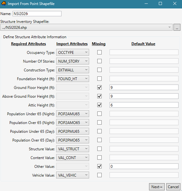
Figure demonstrates the typical associated NSI fields ("Import Attributes") used to populate the LifeSim Import From Point Shapefile Required Attributes. Fields not imported into LifeSim are utilized in pre-processing and refinement of the structure inventory, providing extra information for diagnostic purposes.
Occupancy Types
Source categories are mapped to NSI occupancy types, which are broadly consistent with FEMA Hazus occupancy classifications and USACE consequence modeling needs. Residential occupancy types are further refined during processing based on estimated housing units, number of stories, and basement status. For example, a single-family residential structure is assigned a RES1 subtype that reflects stories and basement condition.
Content values are estimated by multiplying depreciated structure value by an occupancy-specific content-to-structure value ratio. These ratios are shown Table. Applying the ratio to depreciated structure value implicitly assumes a similar degree of depreciation for contents.
The content-to-structure value ratios are based on averages from studies that include expert elicitation, survey data, and claims data. Ratios tend to be higher for occupancy types with specialized equipment or relatively low structure costs. For RES1 structures, the NSI uses a ratio of 0.5. This differs from the 1.0 ratio assumed in USACE Economic Guidance Memorandum (EGM) 04-01. Users applying EGM damage functions calibrated to structure value should use the EGM ratio. For most other applications, the NSI ratio is intended to better approximate typical content value.
| Occupancy Type | Hazus Definition | NSI Content-to-Structure Value | Common Examples |
|---|---|---|---|
| RESIDENTIAL | |||
| RES1-1SNB | Single-Family Dwelling, 1-Story, No Basement | 0.5 | Family home |
| RES1-1SWB | Single-Family Dwelling, 1-Story, w/ Basement | 0.5 | Family home |
| RES1-2SNB | Single-Family Dwelling, 2-Story, No Basement | 0.5 | Family home |
| RES1-2SWB | Single-Family Dwelling, 2-Story, w/ Basement | 0.5 | Family home |
| RES1-3SNB | Single-Family Dwelling, 3-Story, No Basement | 0.5 | Family home |
| RES1-3SWB | Single-Family Dwelling, 3-Story, w/ Basement | 0.5 | Family home |
| RES1-SLNB | Single-Family Dwelling, Split-Level, No Basement | 0.5 | Family home |
| RES1-SLWB | Single-Family Dwelling, Split-Level, w/ Basement | 0.5 | Family home |
| RES2 | Manufactured Home | 1.0 | Mobile home, trailer |
| RES3A | Multi-Family Dwelling, 2 Units | 0.35 | Duplex, home with on-site rental |
| RES3B | Multi-Family Dwelling, 3 to 4 Units | 0.35 | Apartments, condominiums |
| RES3C | Multi-Family Dwelling, 5 to 9 Units | 0.35 | Apartments, condominiums |
| RES3D | Multi-Family Dwelling, 10 to 19 Units | 0.35 | Apartments, condominiums |
| RES3E | Multi-Family Dwelling, 20 to 49 Units | 0.35 | Apartments, condominiums |
| RES3F | Multi-Family Dwelling, 50+ Units | 0.35 | Apartments, condominiums |
| RES4 | Temporary Lodging | 0.45 | Hotel, motel, hostel |
| RES5 | Institutional Dormitory | 0.75 | Prison, school, college dorm |
| RES6 | Nursing Home | 0.95 | Elder care facilities with staff (not senior living) |
| COMMERCIAL | |||
| AGR1 | Agriculture | 1.45 | Ag product and livestock storage, offices, raw material sorting and packaging |
| COM1 | Retail Trade | 1.25 | Department store, strip mall, stores, shops, malls |
| COM2 | Wholesale Trade | 1.4 | Warehouse store, distribution centers |
| COM3 | Personal and Repair Services | 1.5 | Gas and service stations, hair salon |
| COM4 | Business/Professional/Technical Services | 0.55 | Office buildings, shared workspaces |
| COM5 | Banks | 0.6 | Financial services |
| COM6 | Hospital | 1.55 | Emergency rooms, triage, surgery (inpatient) |
| COM7 | Medical Office/Clinic | 1.45 | Dentist, general practitioner (outpatient) |
| COM8 | Entertainment & Recreation | 1.15 | Restaurants |
| COM9 | Theaters | 1.0 | Movie theatre, performance stages |
| COM10 | Parking | 0.25 | Parking lots, parking garages (not dedicated to another building) |
| INDUSTRIAL | |||
| IND1 | Heavy Industrial | 1.7 | Factory |
| IND2 | Light Industrial | 1.7 | Warehouse |
| IND3 | Food/Drugs/Chemicals | 1.7 | Oil refinery, food processing plants |
| IND4 | Metal/Minerals Processing | 1.7 | Mining, manufacture |
| IND5 | High Technology | 1.7 | Research and development labs, server farms |
| IND6 | Construction Facilities and Offices | 1.45 | Buildings under construction, construction material yards (e.g., lumber, gravel, steel), contractor offices |
| PUBLIC | |||
| EDU1 | Schools/Libraries | 0.65 | Grade school, high school, pre-school, administrative offices |
| EDU2 | Colleges/Universities | 0.95 | Classrooms, dining, administration (non-living quarters) |
| GOV1 | General Government Services | 0.7 | City, state, Federal government offices, utility maintenance buildings |
| GOV2 | Emergency Response | 1.15 | Police station, fire station, emergency operations centers, critical function offices |
| REL1 | Church/Non-Profit Organizations | 0.65 | Mosque, Elks Lodge, union hall, Grange (public meeting venue, sporadic use) |
Some noted exclusions from this list include transient facilities like campgrounds, homeless encampments, outdoor markets, stadiums, and arenas. Another example would be large tourist destinations – such as cruise ships in Alaska during the summer – where the population significantly increases during this time but is not accounted for in the census data. If these or other unique facilities are in the floodplain and expected to be populated, the user can create a unique occupancy type in LifeSim.
Structure Values
The NSI provides both full, non-depreciated, replacement value and depreciated replacement value. These values represent the estimated cost to rebuild the structure and may differ significantly from market value. NSI values exclude land value and do not account for market conditions such as demand or location desirability.
USACE analyses typically use depreciated replacement values, while FEMA Hazus applications often use full replacement values.